
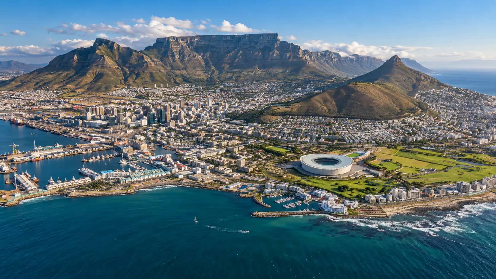
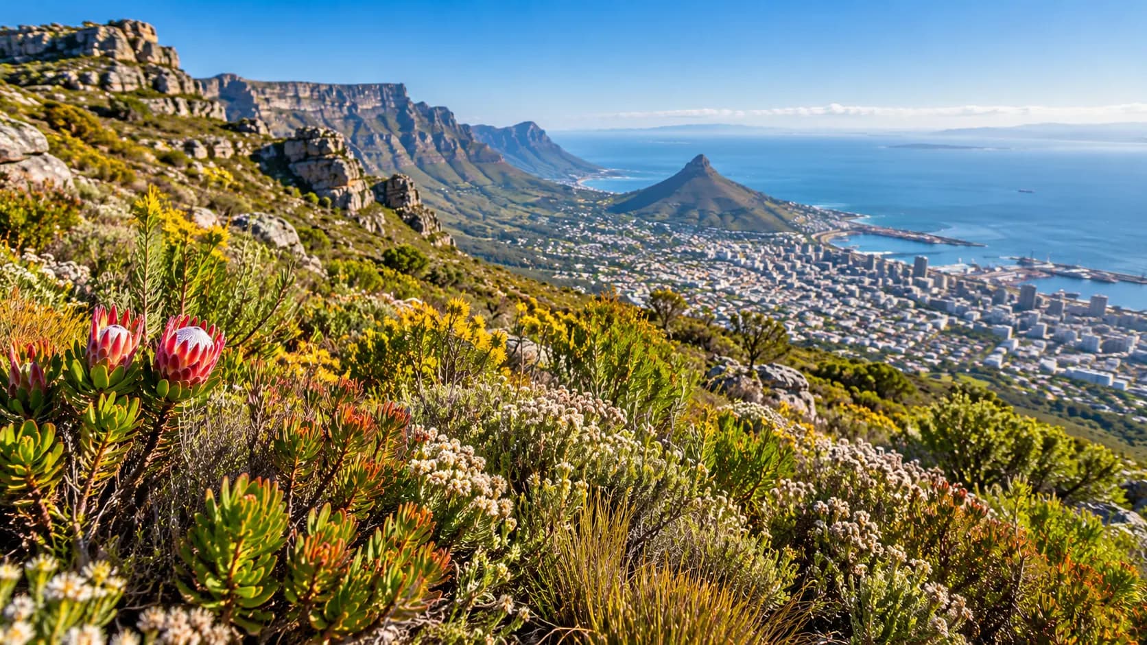
Look at Cape Town from above and the city seems to have been fitted into whatever space nature allowed. Dense neighbourhoods reach toward the coast while Table Mountain rises abruptly behind them. Beaches, cliffs, protected slopes, a working harbour and urban streets all occupy the same metropolitan landscape.
That unusual setting is more than beautiful scenery. Mountains, freshwater, the peninsula and access to the sea influenced where Cape Town developed, how people moved through it and why it became important to maritime trade. Even today, the city's natural geography and human history are difficult to separate.
A City Squeezed Between Mountain and Sea
Cape Town is not simply a coastal city with a mountain in the distance. The mountain system rises directly beside developed neighbourhoods, while the Cape Peninsula extends southward between contrasting coastlines. Cape Town Tourism describes the metropolitan area as a collection of distinct geographic areas, including the Central City, Atlantic Seaboard, Cape Flats, Southern Suburbs and Cape Peninsula.
That geography helps explain why different parts of Cape Town can feel surprisingly separate. Moving a relatively short distance can take someone from dense city streets to steep mountain slopes, exposed Atlantic beaches, sheltered bays or low-lying inland areas.
Table Mountain Did More Than Give Cape Town Its Skyline
Table Mountain is usually treated as Cape Town's visual symbol, but its role in the city's development was practical as well as scenic. Long before European settlement, the wider area was used by Indigenous communities, including San hunter-gatherers and later Khoekhoe pastoralists.
When the Dutch East India Company established a refreshment station at the Cape in 1652, access to fresh water flowing from Table Mountain was an important advantage. The City of Cape Town's own historical account notes that these streams and springs helped make the site suitable for supplying passing ships with water and fresh food.
The settlement then expanded around maritime trade and agriculture. In that sense, the mountain was not merely a backdrop to the early city. The water coming from it helped make the location useful.
Cape Town Has a National Park Running Through It
Another unusual feature is how deeply protected nature extends into the metropolitan landscape. Table Mountain National Park stretches about 70 kilometres from Signal Hill and Table Mountain in the north to Cape Point in the south. It also includes a marine protected area and numerous beaches around the peninsula.
This means that hiking trails, cliffs, native vegetation and wildlife are not confined to a distant reserve outside the city. In many places, the transition from suburb to protected mountain landscape is remarkably abrupt.
The Plants Around Cape Town Are More Extraordinary Than They Look
Cape Town also lies within the broader Cape Floral Region, one of the world's most remarkable centres of plant diversity. UNESCO says the region represents less than 0.5% of Africa's land area yet contains nearly 20% of the continent's flora.
Of an estimated 9,000 plant species in the Cape Floral Region, about 69% are endemic, meaning they occur naturally nowhere else. Those figures describe the wider floral region rather than Cape Town alone, but they help explain why seemingly ordinary mountain slopes around the city can have exceptional conservation value.
Why Fynbos Matters
Much of the characteristic vegetation is known as fynbos. At first glance it can look like low scrub rather than a dramatic forest, yet it contains extraordinary botanical variety. This is one reason the natural landscape around Cape Town is globally important even where it does not appear lush in the conventional sense.
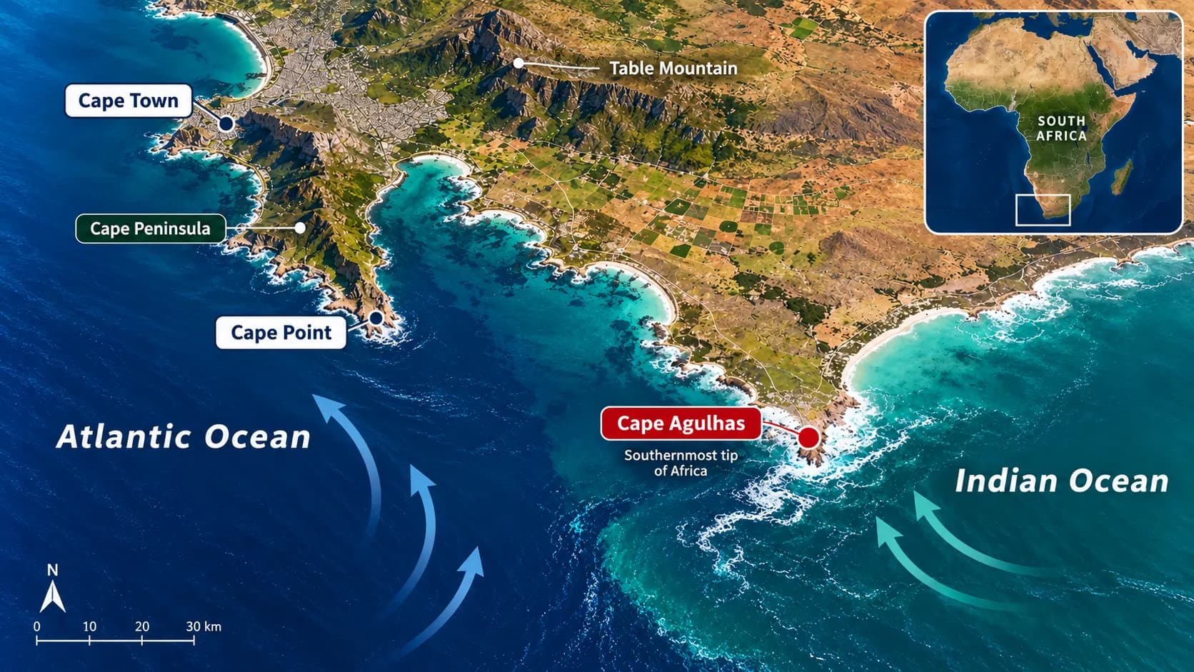
Do the Atlantic and Indian Oceans Really Meet at Cape Point?
This is one of the most repeated Cape Town claims, and it needs a correction. Cape Point sits at the dramatic southern end of the Cape Peninsula and is strongly associated with two-ocean imagery, but South African National Parks identifies Cape Agulhas, farther southeast, as the official meeting point of the Atlantic and Indian Oceans.
Keep reading
The New Seven Wonders of the World and Why They Still Amaze Us
There is no visible line in the water where one ocean suddenly stops and another begins. Ocean boundaries are geographic conventions, while real currents and water masses interact across broad areas. Cape Point remains spectacular, but it is not the officially designated meeting point.
Why Cape Town Became an Important Port
Cape Town's position along maritime routes between Europe and Asia gave the settlement strategic importance. The Dutch refreshment station supplied ships travelling east, and the city later grew as a trade port and agricultural centre.
But describing this simply as the beginning of a successful port would leave out much of the story. Colonial expansion displaced Indigenous communities, and enslaved and indentured people were brought to the Cape from other parts of Africa and across the Indian Ocean world. Their labour, cultures, religions and descendants became part of the city's identity.
Why Is Cape Town Called the Mother City?
Cape Town is widely known as South Africa's Mother City. The nickname is often associated with its age and its early importance in the development of colonial-era urban South Africa. However, there are several popular stories about exactly how the phrase began, and there is no need to pretend that one colourful explanation is definitively proven.
The useful point is that the nickname reflects Cape Town's unusually long urban history compared with many other modern South African cities. The City of Cape Town itself continues to use “Mother City” as a familiar description.
Cape Town's Beauty and Its History Cannot Be Separated
The same harbour, mountain passes, fertile areas and coastal routes that made Cape Town geographically attractive also became part of a history involving colonisation, slavery, migration and unequal access to land.
That history can still be read in places such as the central city, Bo-Kaap, District Six, Robben Island and older settlement routes. Cape Town's cultural diversity did not appear separately from its maritime role; connections across Africa, Europe and the Indian Ocean helped shape it over centuries.
How Apartheid Changed the Shape of the City
Cape Town's present-day geography was also deliberately reshaped during apartheid. Racial segregation and forced removals prevented many non-white residents from living in central areas and suburbs near the city centre and Table Mountain. Communities were displaced, while large numbers of people were moved toward townships and areas on the Cape Flats.
The City of Cape Town acknowledges that evidence of those divisions remains visible in the city's geography today. This matters because the striking physical separation between different parts of Cape Town is not explained by mountains and coastlines alone. Political decisions also helped determine where people could live.
Why Cape Town Can Feel Like Several Different Cities
The Atlantic Seaboard hugs the coast beneath steep slopes. The Central City sits beside the harbour and mountain. The Southern Suburbs spread along another side of the massif. The Cape Flats extend across lower, flatter land, while the peninsula continues south through smaller coastal communities.
These areas differ in landscape, development, history and access. Cape Town Tourism itself describes the city as being made up of several distinct geographic areas. The experience of Cape Town therefore changes dramatically depending on which part of the metropolitan region someone is standing in.
What Makes Cape Town Truly Different
Cape Town is memorable because several powerful stories occupy the same landscape. A globally significant plant region reaches into a major metropolitan area. A national park runs from mountains beside the central city down a long peninsula. An old maritime settlement became a major modern city while retaining visible layers of Indigenous, colonial, slave and apartheid history.
The mountain and ocean may be what first attract the eye, but they are only the beginning. Cape Town feels unusual because nature is not simply somewhere beyond the city. It runs through the city, shaped its origins and still influences how its neighbourhoods connect with one another.
Reference notes
Sources and further reading
- Sanparks (opens in a new tab)https://www.sanparks.org/parks/table%20mountain
- Sanparks (opens in a new tab)https://www.sanparks.org/parks/agulhas/what-to-do/activities/scenic-landmarks
- Whc Unesco (opens in a new tab)https://whc.unesco.org/en/list/1007
Show all 6 sources
- Capetown (opens in a new tab)https://www.capetown.gov.za/local-and-communities/heritage-and-the-community/our-history-and-heritage/what-is-our-history/
- Capetown (opens in a new tab)https://www.capetown.gov.za/explore-and-enjoy/cape-towns-history-and-heritage/heritage-sites-and-buildings/museums-landmarks-and-heritage-sites
- Capetown Travel (opens in a new tab)https://www.capetown.travel/areas/
Our editorial promise
Prepared with clarity and care.
This guide completed our editorial review before publishing. If something needs attention, report a correction or contact the publisher.
About this article
- Published:
- Last updated:
- Author:
- Ceyora Insights
- Review status:
- Editorially reviewed
- Sources:
- 6
- Corrections:
- Report an issue