Think about the world map that hung in your classroom. Greenland may have looked enormous, almost comparable with Africa. Northern countries seemed to dominate the top of the map, while countries closer to the equator appeared smaller.
The countries were never those sizes.
On September 4, 2026, the United Nations General Assembly backed a resolution encouraging wider use of map projections that represent the relative sizes of world regions more accurately. The vote was 164 in favour, one against and six abstentions. Equal Earth was highlighted as an alternative for general world maps.
Nothing happened to Earth's geography that day. What changed was an international recommendation about how we draw it.
Why Is Everyone Talking About a New World Map?
The resolution is called "Correct the Map" and was led by Togo and the African Group, with support from the African Union. Its argument is that commonly seen world maps can give people a misleading visual impression of the relative size of Africa and other regions near the equator.
The decision is not legally binding. It does not order every classroom, publisher or phone app to replace its maps. Instead, it encourages wider use of equal area projections and better education about the limitations of flat maps.
The official UN record also makes clear that the resolution does not modify internationally recognised boundaries. This is a change in representation, not geography.
Was the Old World Map Actually Wrong?
Not in the simple sense that its creator made a mistake.
Gerardus Mercator introduced his famous projection in 1569. It has a valuable mathematical property for navigation: a route that follows a constant compass direction can be represented as a straight line.
The tradeoff is area. The farther a place lies from the equator, the more its area is enlarged on a Mercator world map. That makes northern landmasses appear disproportionately large.
Using Mercator for navigation can therefore make sense. Using the same projection to teach children how large continents are relative to one another creates a different problem.
Why Does Greenland Look Almost as Big as Africa?
This is the comparison that makes Mercator distortion easy to see.
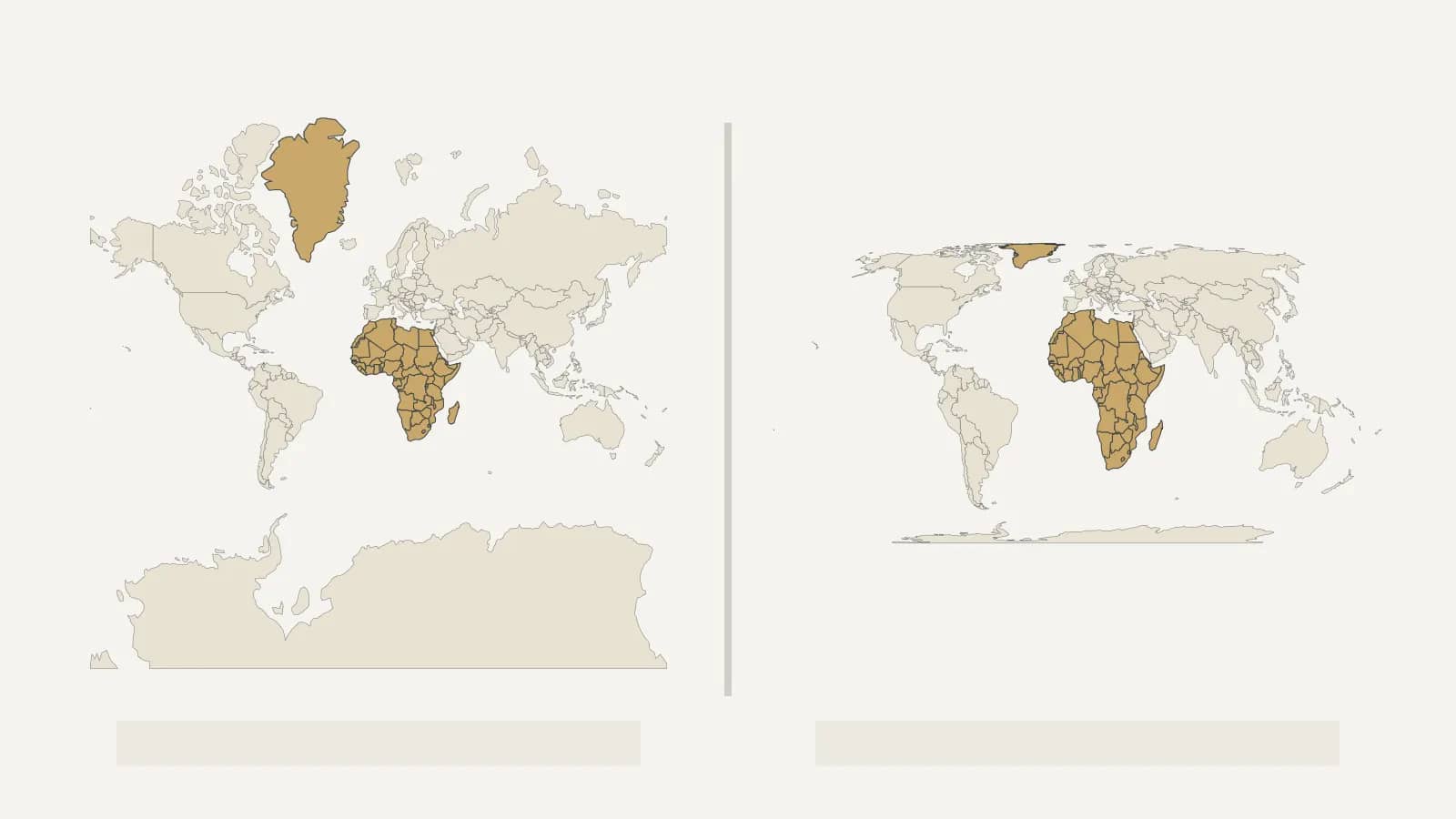
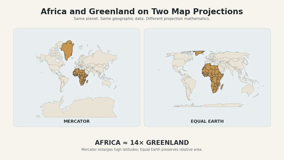
On many Mercator maps, Greenland appears surprisingly close to Africa in visual size. In reality, Africa is about 14 times larger.
Africa lies across the equator, where Mercator distortion is much smaller. Greenland sits much farther north, where the projection expands areas dramatically.
Greenland has not been drawn badly in isolation. The projection is stretching the map more and more as it approaches the poles.
Why Can't One Flat Map Show Everything Perfectly?
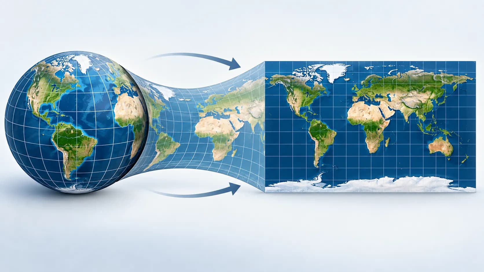
Because Earth is curved and a sheet of paper or computer screen is flat.
Imagine peeling an orange and trying to press the peel into a perfect rectangle without tearing, stretching or overlapping it. Something has to give. Cartographers face the mathematical version of that problem whenever they turn the globe into a flat world map.
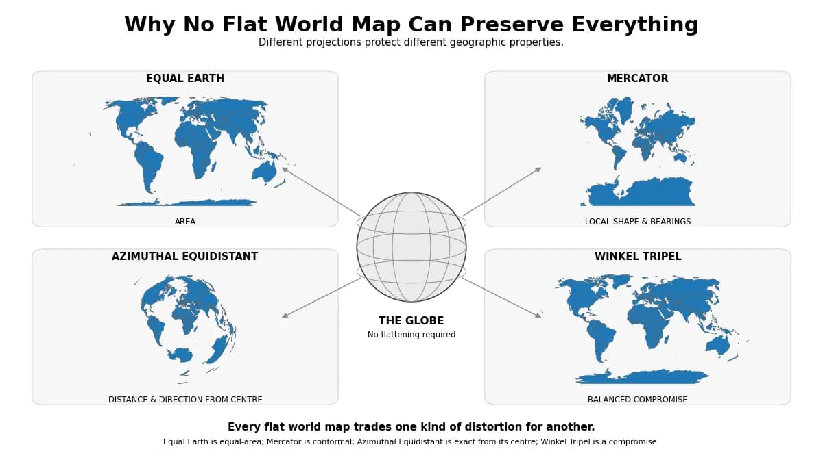
The US Geological Survey explains that no flat world map can preserve true direction, distance, area and shape everywhere at the same time. Different projections choose different priorities.
Mercator is strong at preserving local angles and compass direction. Equal area maps preserve relative surface area. Other projections try to find a visually pleasing compromise among several types of distortion.
What Is the Equal Earth Map?
Equal Earth is a world map projection created in 2018 by cartographers Bojan Šavrič, Tom Patterson and Bernhard Jenny.
Keep reading
How Does the Tour de France Actually Work?
Its defining property is that it is an equal area projection. If one region covers twice as much surface area on Earth as another, it also occupies twice as much area on the map.
Its overall outline was designed to remain visually familiar, with curved outer edges that hint at the shape of a globe. That makes it easier for many readers to recognise continents compared with some older equal area projections.
Equal Earth does not eliminate distortion. Shapes, angles and distances still change in places. What it protects is relative area.
Why Does Africa Suddenly Look Much Bigger?
It does not suddenly become bigger. It stops being visually disadvantaged by the projection.
On Equal Earth, the area occupied by Africa is proportional to its actual share of Earth's surface. Greenland, northern Canada, Russia and other high latitude regions no longer receive the enormous area enlargement produced by Mercator.
The effect can feel surprising only because the distorted version is the one many people learned first.
Does This Mean Mercator Maps Will Disappear?
No.
The UN resolution does not ban Mercator, and it explicitly leaves legitimate navigation uses unaffected. Constant compass bearings appearing as straight lines remain a useful property for nautical navigation.
The broader lesson is that a map should fit its purpose. A projection useful for plotting a course across the ocean does not automatically make the best classroom poster for comparing continental size.
Will Google Maps and Other Apps Change?
The resolution encourages technology and mapping organisations to consider more representative projections, but it does not compel a company to redesign its service.
As of September 11, 2026, there is no basis for saying that Google Maps or every major mapping platform has committed to switching its general map display to Equal Earth because of the UN vote.
Digital mapping also has different technical needs from a printed world map. The best projection for viewing the whole planet is not necessarily the projection chosen for zooming into streets, routes and local navigation.
Is Equal Earth the One Completely Accurate World Map?
No flat projection deserves that description.
Equal Earth accurately preserves relative area, which makes it especially useful when the size of countries and continents matters. But it still distorts other geometric properties because that tradeoff cannot be avoided on a flat world map.
If you want the closest intuitive representation of the planet's overall geometry, a globe avoids the fundamental flattening problem. Even then, a physical globe has practical limits of scale and detail.
The Planet Did Not Change. Our View of It Did
The debate over the new world map is really about what happens when a tool designed for one purpose becomes the picture generations use to imagine the whole planet.
Mercator solved an important navigation problem. Equal Earth solves a different one by keeping the relative area of continents in proportion.
Once you see Africa beside Greenland on an equal area map, it can be difficult to look at the familiar classroom map in quite the same way.
The borders have not moved. Africa has not grown. Greenland has not shrunk. What changed is the lens.
Reference notes
Sources and further reading
- Un (opens in a new tab)https://www.un.org/osaa/en/news/victory-africa-un-votes-resolution-correct-map
- Public E Delegate Un (opens in a new tab)https://public.e-delegate.un.org/reports/ga80_schedule.html
- Transcripts Un (opens in a new tab)https://transcripts.un.org/en/ga/80/114
Show all 10 sources
- Docs Un (opens in a new tab)https://docs.un.org/A/80/L.104
- Reuters (opens in a new tab)https://www.reuters.com/world/africa/un-approves-resolution-support-map-that-shows-africas-true-size-2026-09-04/
- Usgs (opens in a new tab)https://www.usgs.gov/faqs/how-are-different-map-projections-used
- Doc Esri (opens in a new tab)https://doc.esri.com/en/arcgis-pro/latest/help/mapping/properties/mercator.html
- Doi (opens in a new tab)https://doi.org/10.1080/13658816.2018.1504949
- Proj (opens in a new tab)https://proj.org/en/stable/operations/projections/eqearth.html
- Equal Earth (opens in a new tab)https://www.equal-earth.com/equal-earth-projection.html
Our editorial promise
Prepared with clarity and care.
This guide completed our editorial review before publishing. If something needs attention, report a correction or contact the publisher.
About this article
- Published:
- Last updated:
- Author:
- Ceyora Editorial Team
- Review status:
- Editorially reviewed
- Sources:
- 10
- Corrections:
- Report an issue